News
Atlantic Canada Braces For Fiona
Major Impacts Anticipated

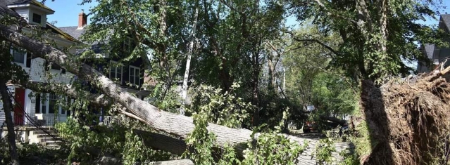
Damage Caused By Hurricane Jaun 2003/Halifax (Source: Brian Teepell Photography)
USPA NEWS -
UPDATED 1800, September 22nd, 2022: Environment Canada has issued tropical storm watches, and hurricane watches/warnings across the Atlantic region in anticipation of Hurricane Fiona.
A watch means that hurricane or tropical storm conditions are possible in the alerted area within 36 hours.
A watch means that hurricane or tropical storm conditions are possible in the alerted area within 36 hours.
As reported by Kalin Mitchell, Chief Meteorologist for CTV Atlantic:
"Hurricane Fiona continues to pick up speed towards the north as a Category 4 hurricane, now moving at nearly 25 kilometres per hour. The storm is forecast to pass to the west of Bermuda and enter the Scotian Slope marine waters of Atlantic Canada as a Category 3 hurricane on Friday."
"Landfall as a powerful post-tropical storm, equivalent to a Category 1 or 2 hurricane looks increasingly likely in eastern Nova Scotia Saturday morning. The forecast cone for that landfall has now narrowed to span eastern Halifax County across Cape Breton. Various computer models show a landfall somewhere in the area from Canso to near Louisbourg in Nova Scotia between 6 a.m. and 10 a.m. Saturday. Weather conditions in the Maritimes will deteriorate Friday night into Saturday morning."
"Torrential rain is expected for eastern parts of the Maritimes Friday night into Saturday morning. Friday through Saturday could see rain totals of 80 to 200 millimetres in eastern P.E.I. and eastern Nova Scotia increasing the risk of flash flooding and washouts. Rainfall totals could reach 50 to 80 millimetres extending towards the west of P.E.I. and central areas of Nova Scotia. There is potential for heavy rainfalls to quickly move into New Brunswick and the southwest of Nova Scotia."
"Wind will increase in strength for much of the Maritimes Friday night into Saturday morning. Peak gusts in eastern Nova Scotia and P.E.I. could reach 120 to 150 kilometres per hour due to being in proximity to the centre of the storm as it passes. That said, widespread gusts reaching 90 to 120 kilomtres per hours look possible, extending as far west as Halifax in Nova Scotia. Gusts reaching 70 to 90 kilometres per hour could possibly extend into the southwest of Nova Scotia and eastern New Brunswick. Wind direction will primarily be out of the north and northwest. The exception is the area east of the landfall point, most likely Cape Breton, where the direction will be easterly turning southerly. Wind of that strength will have the potential to cause power outages. In the eastern part of the region, where the wind is forecast to be strongest, there is an increased risk of falling trees and branches. Where the wind is onshore, it will help to produce a ferocious surf and risk of storm surge."
"The greatest risk of a damaging storm surge looks to be the eastern and northern coastlines of Nova Scotia, the southeastern coastline of New Brunswick, and the northern coastline of P.E.I. The very low barometric pressure in the centre of the storm will allow for ocean water to rise up under it. Intense winds will increase wave action against the coast further increasing the risk of flooding or damage. Near coastal waves reaching 10 metres, or 30 feet, may be present on the eastern shore of Nova Scotia late Friday night into Saturday morning."
Representatives from the Emergency Management Office, Nova Scotia Power along with municipal and provincial government officials spoke with media by video conference about preparations for the approaching storm. Below are some of the highlights.
"People should monitor local weather forecasts and prepare for the storm's arrival. The basic checklist includes: having enough food and water for 72 hours, monitoring local media outlets for updates, securing gates, doors and windows, moving yard furniture and securing trash cans, hanging plants and anything that can be picked up by wind, checking radio batteries, filling vehicles with gas and parking them away from trees, keeping pets inside, moving any type of watercraft to high ground, ensuring personal and family safety, checking on neighbours, not leaving candles unattended, making sure mobile devices are charged, stocking up on medication to last a period of 72 hours, and not travelling during the passage of the storm and the worst of the inclement weather."
"Every household should have an emergency kit which contains the following: flashlights, batteries, water (Fill up jugs for drinking, fill up the tub for toilet flushing, fill up a jug for hand washing and teeth brushing),non-perishable food for 3 days (bread, peanut butter, canned tuna and meats, canned veggies and fruits, snacks, and cereals) and
warm blankets and clothing."
Liability for this article lies with the author, who also holds the copyright. Editorial content from USPA may be quoted on other websites as long as the quote comprises no more than 5% of the entire text, is marked as such and the source is named (via hyperlink).


